Search
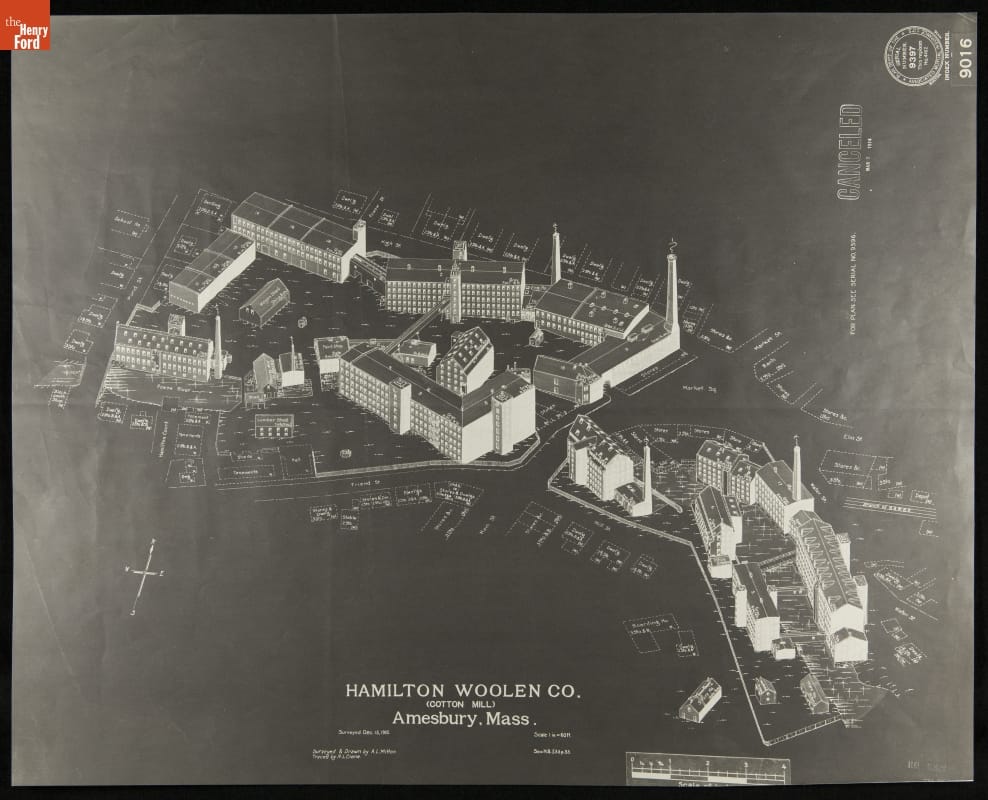
- Fire Insurance Map of Hamilton Woolen Co., Amesbury, Massachusetts, Surveyed December 15, 1910 - Fire insurance maps provided information to insurance companies about potential risks to homes, businesses, and factories. These maps -- with their easily identifiable symbols and color-coding -- depicted structural features, types of construction, and locations of fire hazards. Armed with this information, insurance underwriters could propose reasonable rates and offer protection against possible catastrophic financial loss in the event of a fire.
- December 15, 1910
- Collections - Artifact
Fire Insurance Map of Hamilton Woolen Co., Amesbury, Massachusetts, Surveyed December 15, 1910
Fire insurance maps provided information to insurance companies about potential risks to homes, businesses, and factories. These maps -- with their easily identifiable symbols and color-coding -- depicted structural features, types of construction, and locations of fire hazards. Armed with this information, insurance underwriters could propose reasonable rates and offer protection against possible catastrophic financial loss in the event of a fire.
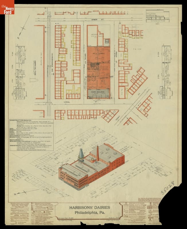
- Fire Insurance Map of Harbison's Dairies, Philadelphia, Pennsylvania, Surveyed September 29, 1916 - Fire insurance maps provided information to insurance companies about potential risks to homes, businesses, and factories. These maps -- with their easily identifiable symbols and color-coding -- depicted structural features, types of construction, and locations of fire hazards. Armed with this information, insurance underwriters could propose reasonable rates and offer protection against possible catastrophic financial loss in the event of a fire.
- September 29, 1916
- Collections - Artifact
Fire Insurance Map of Harbison's Dairies, Philadelphia, Pennsylvania, Surveyed September 29, 1916
Fire insurance maps provided information to insurance companies about potential risks to homes, businesses, and factories. These maps -- with their easily identifiable symbols and color-coding -- depicted structural features, types of construction, and locations of fire hazards. Armed with this information, insurance underwriters could propose reasonable rates and offer protection against possible catastrophic financial loss in the event of a fire.
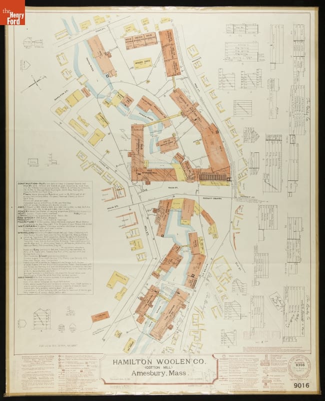
- Fire Insurance Map of Hamilton Woolen Co., Amesbury, Massachusetts, Surveyed December 15, 1910 - Fire insurance maps provided information to insurance companies about potential risks to homes, businesses, and factories. These maps -- with their easily identifiable symbols and color-coding -- depicted structural features, types of construction, and locations of fire hazards. Armed with this information, insurance underwriters could propose reasonable rates and offer protection against possible catastrophic financial loss in the event of a fire.
- December 15, 1910
- Collections - Artifact
Fire Insurance Map of Hamilton Woolen Co., Amesbury, Massachusetts, Surveyed December 15, 1910
Fire insurance maps provided information to insurance companies about potential risks to homes, businesses, and factories. These maps -- with their easily identifiable symbols and color-coding -- depicted structural features, types of construction, and locations of fire hazards. Armed with this information, insurance underwriters could propose reasonable rates and offer protection against possible catastrophic financial loss in the event of a fire.
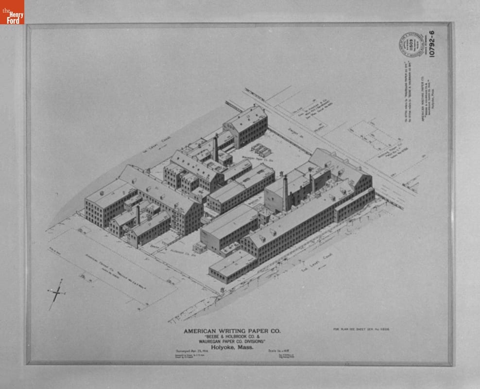
- Fire Insurance Map of the American Writing Paper Co., Holyoke, Massachusetts, Surveyed April 23, 1914 - Fire insurance maps provided information to insurance companies about potential risks to homes, businesses, and factories. These maps -- with their easily identifiable symbols and color-coding -- depicted structural features, types of construction, and locations of fire hazards. Armed with this information, insurance underwriters could propose reasonable rates and offer protection against possible catastrophic financial loss in the event of a fire.
- April 23, 1914
- Collections - Artifact
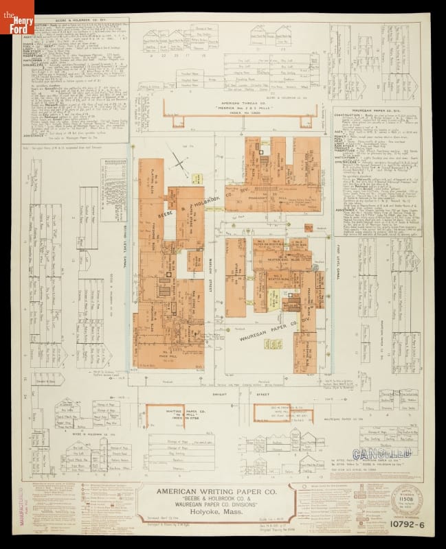
Fire Insurance Map of the American Writing Paper Co., Holyoke, Massachusetts, Surveyed April 23, 1914
Fire insurance maps provided information to insurance companies about potential risks to homes, businesses, and factories. These maps -- with their easily identifiable symbols and color-coding -- depicted structural features, types of construction, and locations of fire hazards. Armed with this information, insurance underwriters could propose reasonable rates and offer protection against possible catastrophic financial loss in the event of a fire.
- Fire Insurance Map of the American Writing Paper Co., Holyoke, Massachusetts, Surveyed April 23, 1914 - Fire insurance maps provided information to insurance companies about potential risks to homes, businesses, and factories. These maps -- with their easily identifiable symbols and color-coding -- depicted structural features, types of construction, and locations of fire hazards. Armed with this information, insurance underwriters could propose reasonable rates and offer protection against possible catastrophic financial loss in the event of a fire.
- April 23, 1914
- Collections - Artifact
Fire Insurance Map of the American Writing Paper Co., Holyoke, Massachusetts, Surveyed April 23, 1914
Fire insurance maps provided information to insurance companies about potential risks to homes, businesses, and factories. These maps -- with their easily identifiable symbols and color-coding -- depicted structural features, types of construction, and locations of fire hazards. Armed with this information, insurance underwriters could propose reasonable rates and offer protection against possible catastrophic financial loss in the event of a fire.
- Fire Insurance Map of American Steel Foundries "Sharon Works," Hickory Township, Pennsylvania, Surveyed August 1, 1913 - Fire insurance maps provided information to insurance companies about potential risks to homes, businesses, and factories. These maps -- with their easily identifiable symbols and color-coding -- depicted structural features, types of construction, and locations of fire hazards. Armed with this information, insurance underwriters could propose reasonable rates and offer protection against possible catastrophic financial loss in the event of a fire.
- August 01, 1913
- Collections - Artifact
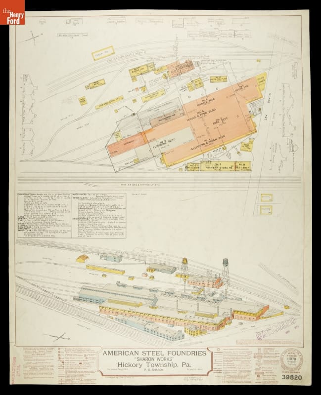
Fire Insurance Map of American Steel Foundries "Sharon Works," Hickory Township, Pennsylvania, Surveyed August 1, 1913
Fire insurance maps provided information to insurance companies about potential risks to homes, businesses, and factories. These maps -- with their easily identifiable symbols and color-coding -- depicted structural features, types of construction, and locations of fire hazards. Armed with this information, insurance underwriters could propose reasonable rates and offer protection against possible catastrophic financial loss in the event of a fire.