Search
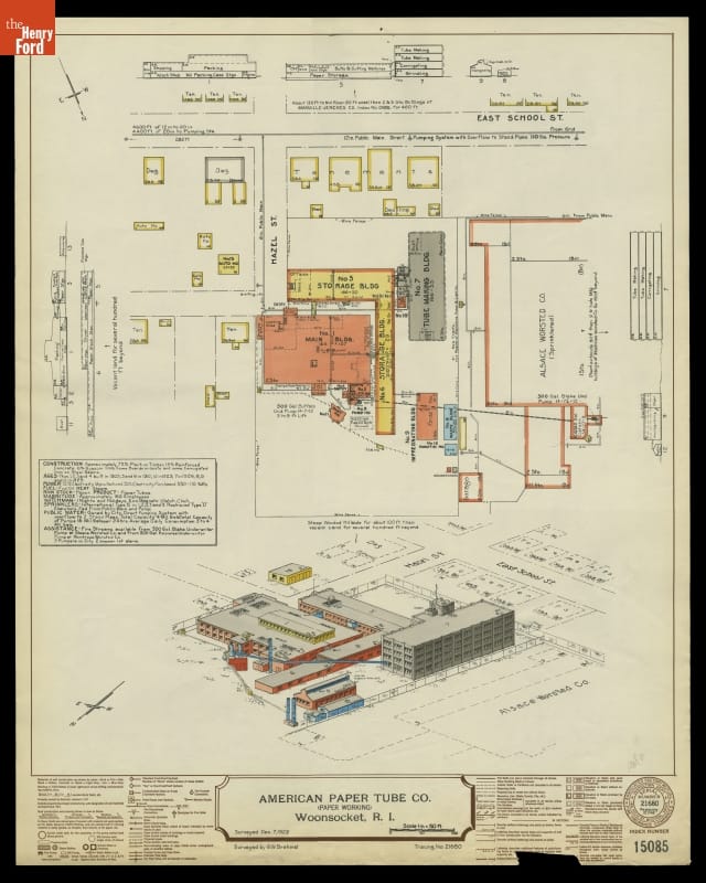
- Fire Insurance Map of the American Paper Tube Co., Woonsocket, Rhode Island, Surveyed December 7, 1929 - Fire insurance maps provided information to insurance companies about potential risks to homes, businesses, and factories. These maps -- with their easily identifiable symbols and color-coding -- depicted structural features, types of construction, and locations of fire hazards. Armed with this information, insurance underwriters could propose reasonable rates and offer protection against possible catastrophic financial loss in the event of a fire.
- December 07, 1929
- Collections - Artifact
Fire Insurance Map of the American Paper Tube Co., Woonsocket, Rhode Island, Surveyed December 7, 1929
Fire insurance maps provided information to insurance companies about potential risks to homes, businesses, and factories. These maps -- with their easily identifiable symbols and color-coding -- depicted structural features, types of construction, and locations of fire hazards. Armed with this information, insurance underwriters could propose reasonable rates and offer protection against possible catastrophic financial loss in the event of a fire.
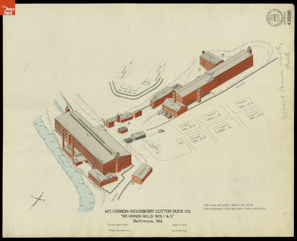
- Fire Insurance Map of the Mt. Vernon-Woodberry Cotton Duck Co., Baltimore, Maryland, Surveyed March 14, 1902 - Fire insurance maps provided information to insurance companies about potential risks to homes, businesses, and factories. These maps -- with their easily identifiable symbols and color-coding -- depicted structural features, types of construction, and locations of fire hazards. Armed with this information, insurance underwriters could propose reasonable rates and offer protection against possible catastrophic financial loss in the event of a fire.
- March 14, 1902
- Collections - Artifact
Fire Insurance Map of the Mt. Vernon-Woodberry Cotton Duck Co., Baltimore, Maryland, Surveyed March 14, 1902
Fire insurance maps provided information to insurance companies about potential risks to homes, businesses, and factories. These maps -- with their easily identifiable symbols and color-coding -- depicted structural features, types of construction, and locations of fire hazards. Armed with this information, insurance underwriters could propose reasonable rates and offer protection against possible catastrophic financial loss in the event of a fire.
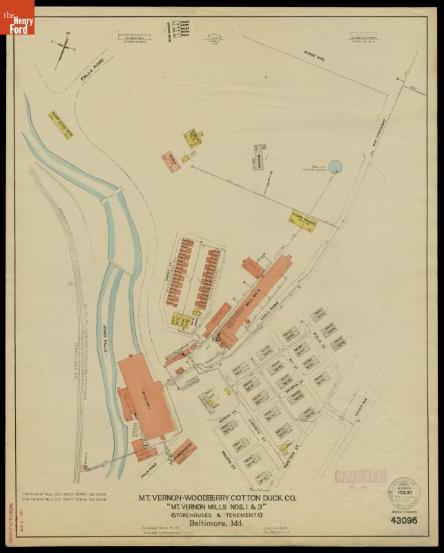
- Fire Insurance Map of the Mt. Vernon-Woodberry Cotton Duck Co., Baltimore, Maryland, Surveyed March 14, 1912 - Fire insurance maps provided information to insurance companies about potential risks to homes, businesses, and factories. These maps -- with their easily identifiable symbols and color-coding -- depicted structural features, types of construction, and locations of fire hazards. Armed with this information, insurance underwriters could propose reasonable rates and offer protection against possible catastrophic financial loss in the event of a fire.
- March 14, 1912
- Collections - Artifact
Fire Insurance Map of the Mt. Vernon-Woodberry Cotton Duck Co., Baltimore, Maryland, Surveyed March 14, 1912
Fire insurance maps provided information to insurance companies about potential risks to homes, businesses, and factories. These maps -- with their easily identifiable symbols and color-coding -- depicted structural features, types of construction, and locations of fire hazards. Armed with this information, insurance underwriters could propose reasonable rates and offer protection against possible catastrophic financial loss in the event of a fire.
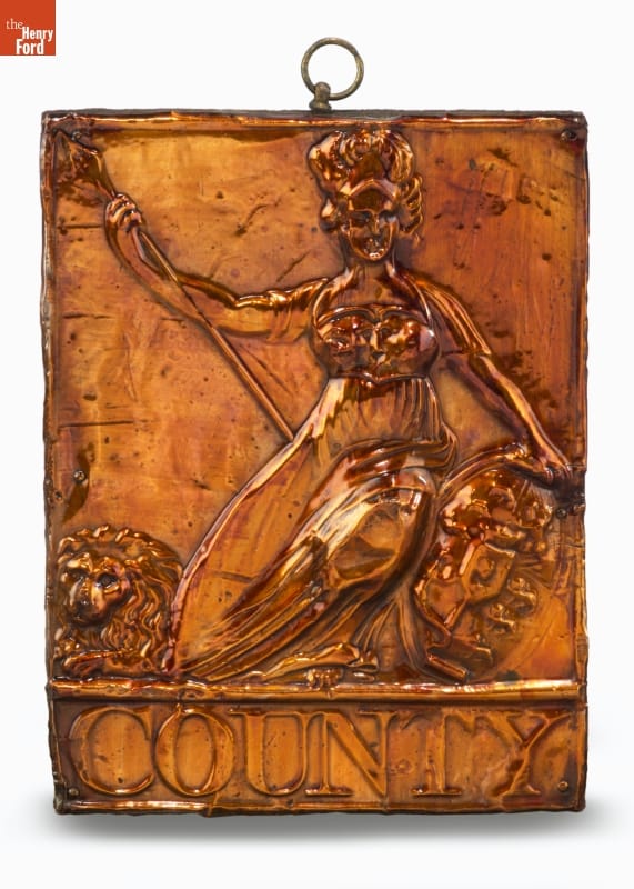
- County Fire Insurance Mark -
- Collections - Artifact
County Fire Insurance Mark
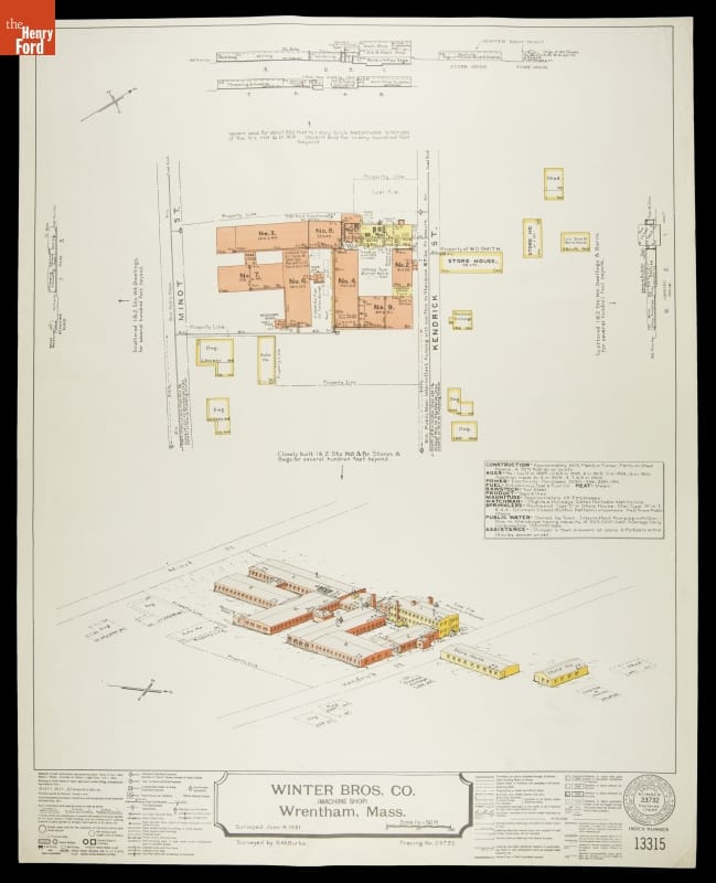
- Fire Insurance Map of Winter Bros. Co., Wrentham, Massachusetts, Surveyed June 4, 1931 - Fire insurance maps provided information to insurance companies about potential risks to homes, businesses, and factories. These maps -- with their easily identifiable symbols and color-coding -- depicted structural features, types of construction, and locations of fire hazards. Armed with this information, insurance underwriters could propose reasonable rates and offer protection against possible catastrophic financial loss in the event of a fire.
- June 04, 1931
- Collections - Artifact
Fire Insurance Map of Winter Bros. Co., Wrentham, Massachusetts, Surveyed June 4, 1931
Fire insurance maps provided information to insurance companies about potential risks to homes, businesses, and factories. These maps -- with their easily identifiable symbols and color-coding -- depicted structural features, types of construction, and locations of fire hazards. Armed with this information, insurance underwriters could propose reasonable rates and offer protection against possible catastrophic financial loss in the event of a fire.
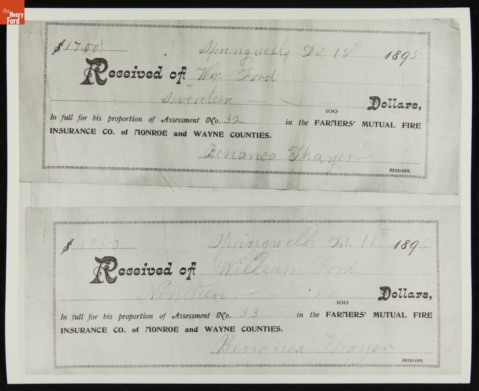
- Receipts for Insurance Payments Made by William Ford (Henry Ford's Father), Springwells Township, Michigan, 1895 - When William Ford, Henry Ford's father, emigrated from Ireland in 1847 at the age of twenty he had little wealth. William settled near family in southeast Michigan and eventually purchased a tract of land. By the late 19th century, William was a prosperous farmer and secure enough to protect his property with insurance.
- 1895
- Collections - Artifact
Receipts for Insurance Payments Made by William Ford (Henry Ford's Father), Springwells Township, Michigan, 1895
When William Ford, Henry Ford's father, emigrated from Ireland in 1847 at the age of twenty he had little wealth. William settled near family in southeast Michigan and eventually purchased a tract of land. By the late 19th century, William was a prosperous farmer and secure enough to protect his property with insurance.
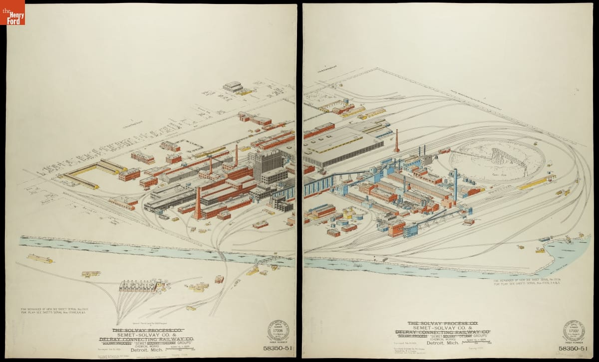
- Fire Insurance Map of the Semet-Solvay Co. & Semet Groups Chemical Works, Detroit, Michigan, February 21, 1925 - Fire insurance maps provided information to insurance companies about potential risks to homes, businesses, and factories. These maps -- with their easily identifiable symbols and color-coding -- depicted structural features, types of construction, and locations of fire hazards. Armed with this information, insurance underwriters could propose reasonable rates and offer protection against possible catastrophic financial loss in the event of a fire.
- February 21, 1925
- Collections - Artifact
Fire Insurance Map of the Semet-Solvay Co. & Semet Groups Chemical Works, Detroit, Michigan, February 21, 1925
Fire insurance maps provided information to insurance companies about potential risks to homes, businesses, and factories. These maps -- with their easily identifiable symbols and color-coding -- depicted structural features, types of construction, and locations of fire hazards. Armed with this information, insurance underwriters could propose reasonable rates and offer protection against possible catastrophic financial loss in the event of a fire.
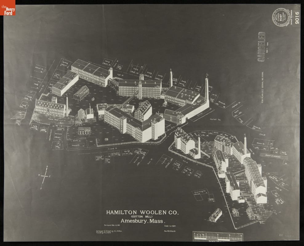
- Fire Insurance Map of Hamilton Woolen Co., Amesbury, Massachusetts, Surveyed December 15, 1910 - Fire insurance maps provided information to insurance companies about potential risks to homes, businesses, and factories. These maps -- with their easily identifiable symbols and color-coding -- depicted structural features, types of construction, and locations of fire hazards. Armed with this information, insurance underwriters could propose reasonable rates and offer protection against possible catastrophic financial loss in the event of a fire.
- December 15, 1910
- Collections - Artifact
Fire Insurance Map of Hamilton Woolen Co., Amesbury, Massachusetts, Surveyed December 15, 1910
Fire insurance maps provided information to insurance companies about potential risks to homes, businesses, and factories. These maps -- with their easily identifiable symbols and color-coding -- depicted structural features, types of construction, and locations of fire hazards. Armed with this information, insurance underwriters could propose reasonable rates and offer protection against possible catastrophic financial loss in the event of a fire.
- Office of the German Fire Insurance Company of Preble Township, Indiana, circa 1898 -
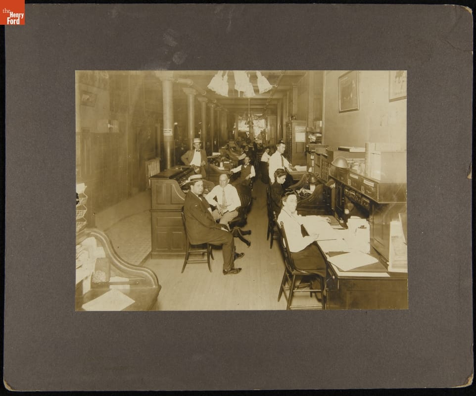
- circa 1898
- Collections - Artifact
Office of the German Fire Insurance Company of Preble Township, Indiana, circa 1898
- Fire Insurance Map of Briggs Mfg. Co. at Ford Motor Company Highland Park Plant, Surveyed May 23, 1924 - Fire insurance maps provided information to insurance companies about potential risks to homes, businesses, and factories. These maps -- with their easily identifiable symbols and color-coding -- depicted structural features, types of construction, and locations of fire hazards. Armed with this information, insurance underwriters could propose reasonable rates and offer protection against possible catastrophic financial loss in the event of a fire.
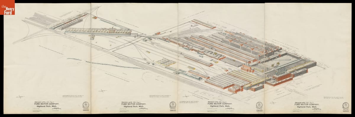
- May 23, 1924
- Collections - Artifact
Fire Insurance Map of Briggs Mfg. Co. at Ford Motor Company Highland Park Plant, Surveyed May 23, 1924
Fire insurance maps provided information to insurance companies about potential risks to homes, businesses, and factories. These maps -- with their easily identifiable symbols and color-coding -- depicted structural features, types of construction, and locations of fire hazards. Armed with this information, insurance underwriters could propose reasonable rates and offer protection against possible catastrophic financial loss in the event of a fire.