Search
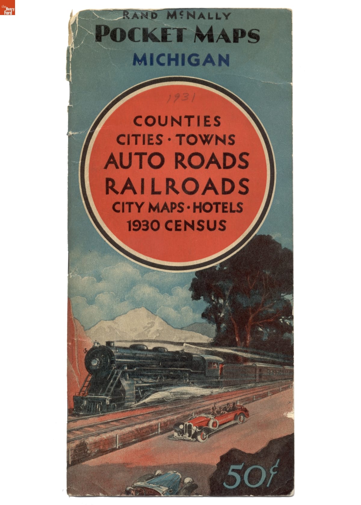
- Rand McNally Pocket Map of Michigan, 1931 - After the federal government established a system of numbered and marked highways in 1926, road maps became more popular. Rand McNally published this pocket map of Michigan's road network in 1931. The map also included railroad lines, hotels, detailed maps of major cities, and population information from the 1930 census.
- 1931
- Collections - Artifact
Rand McNally Pocket Map of Michigan, 1931
After the federal government established a system of numbered and marked highways in 1926, road maps became more popular. Rand McNally published this pocket map of Michigan's road network in 1931. The map also included railroad lines, hotels, detailed maps of major cities, and population information from the 1930 census.
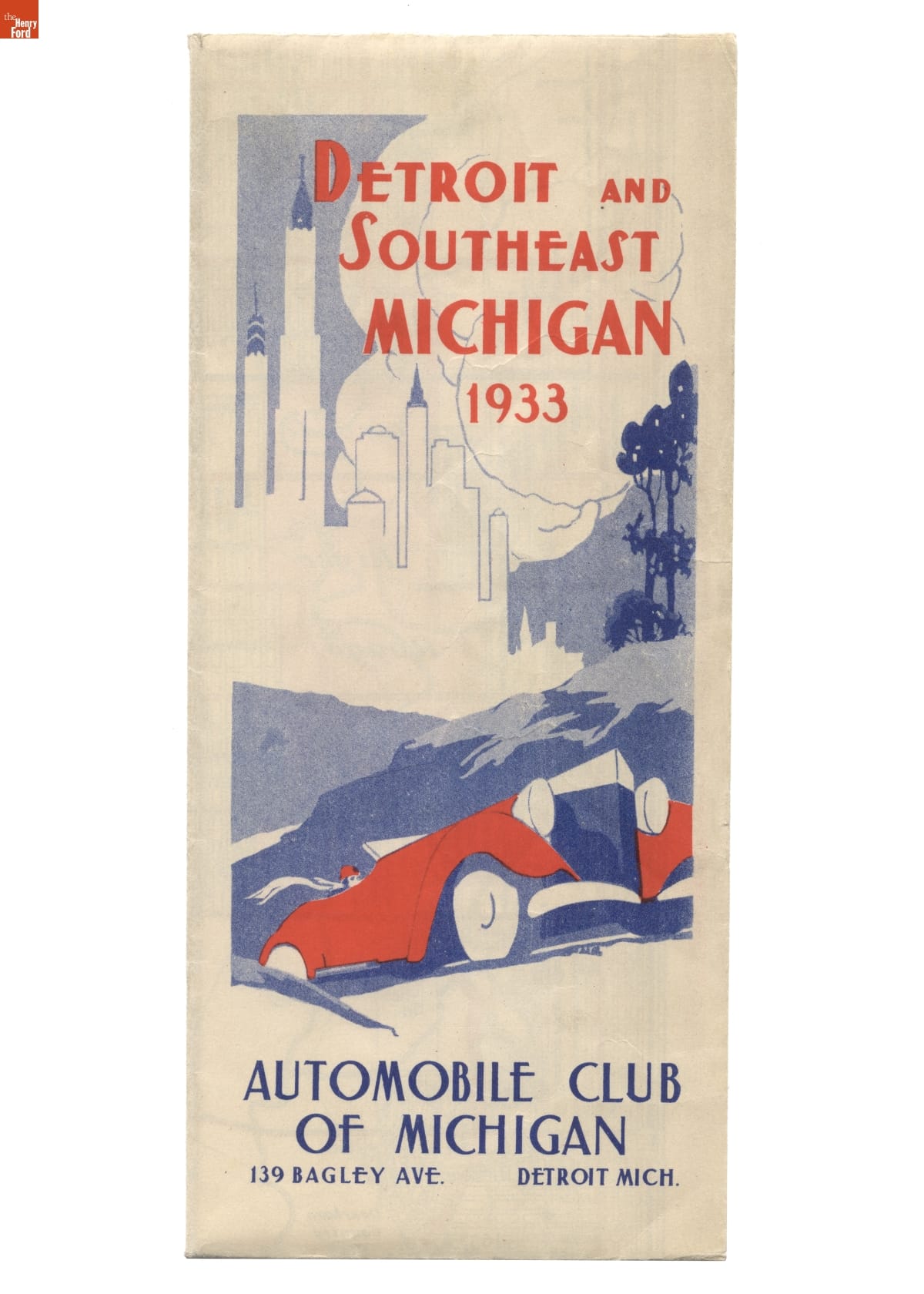
- Road Map for Detroit and Southeast Michigan, 1933 - After the federal government established a system of numbered and marked highways in 1926, road maps became more popular. The Automobile Club of Michigan published this 1933 map of roads in Detroit and surrounding areas in southeast Michigan. Road maps encouraged tourism and economic development.
- 1933
- Collections - Artifact
Road Map for Detroit and Southeast Michigan, 1933
After the federal government established a system of numbered and marked highways in 1926, road maps became more popular. The Automobile Club of Michigan published this 1933 map of roads in Detroit and surrounding areas in southeast Michigan. Road maps encouraged tourism and economic development.
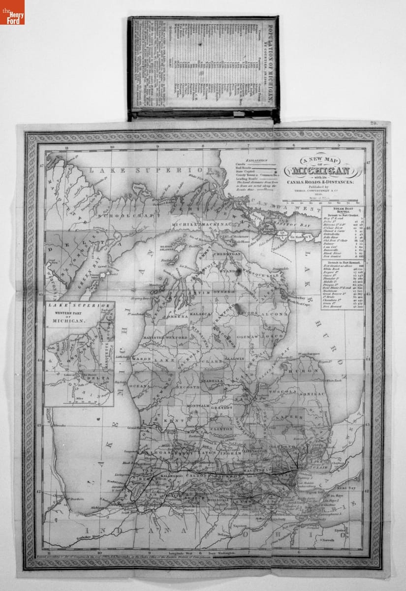
- Mitchell's Map of Michigan, 1850 - This map shows Michigan in 1850, some 13 years after it achieved statehood. Cities were still largely confined to the southern Lower Peninsula. The map also includes major rivers and the state's emerging railroad network. The latter was dominated by the Michigan Central Railroad, running west from Detroit toward Chicago via Ann Arbor, Jackson, Battle Creek, and Kalamazoo.
- 1850
- Collections - Artifact
Mitchell's Map of Michigan, 1850
This map shows Michigan in 1850, some 13 years after it achieved statehood. Cities were still largely confined to the southern Lower Peninsula. The map also includes major rivers and the state's emerging railroad network. The latter was dominated by the Michigan Central Railroad, running west from Detroit toward Chicago via Ann Arbor, Jackson, Battle Creek, and Kalamazoo.
- 1938 Road Map of Germany -

- 1938
- Collections - Artifact
1938 Road Map of Germany
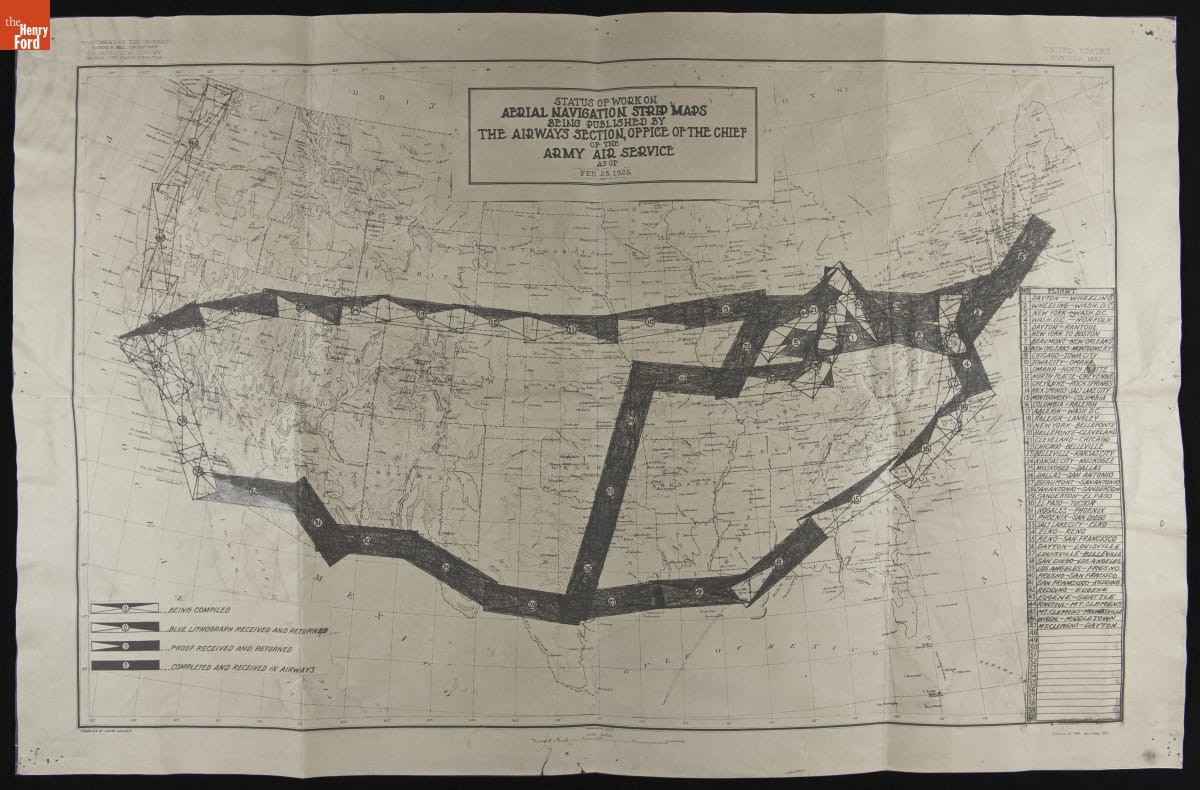
- Status of Work on Aerial Navigation Strip Maps Being Published by the Army Air Service as of February 25, 1925 - Navigating in an early airplane -- without the benefit of sophisticated cockpit instruments or radio communication -- wasn't easy. The U.S. Army, in cooperation with the U.S. Post Office, established a network of flyways across the country. These routes were marked with lighted beacons, creating reliable paths that pilots could follow day and night.
- February 25, 1925
- Collections - Artifact
Status of Work on Aerial Navigation Strip Maps Being Published by the Army Air Service as of February 25, 1925
Navigating in an early airplane -- without the benefit of sophisticated cockpit instruments or radio communication -- wasn't easy. The U.S. Army, in cooperation with the U.S. Post Office, established a network of flyways across the country. These routes were marked with lighted beacons, creating reliable paths that pilots could follow day and night.
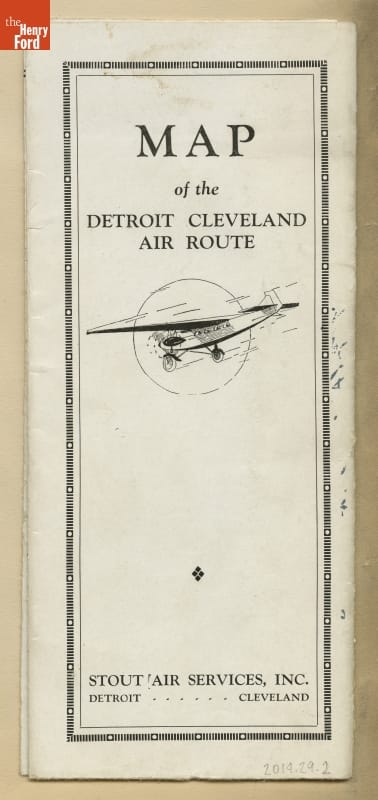
- Map of the Stout Air Services' Detroit-to-Cleveland Air Route, circa 1928 - Stout Air Services offered scheduled passenger flights between Detroit and Cleveland in the late 1920s. The travel time was 100 minutes. Instead of flying directly across Lake Erie, pilots took the overland route seen on this map. This routing allowed pilots to navigate by visible landmarks and gave them places to land in the event of an emergency.
- circa 1928
- Collections - Artifact
Map of the Stout Air Services' Detroit-to-Cleveland Air Route, circa 1928
Stout Air Services offered scheduled passenger flights between Detroit and Cleveland in the late 1920s. The travel time was 100 minutes. Instead of flying directly across Lake Erie, pilots took the overland route seen on this map. This routing allowed pilots to navigate by visible landmarks and gave them places to land in the event of an emergency.
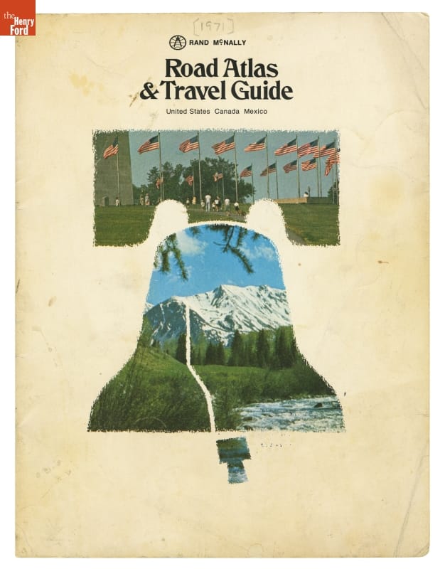
- Rand McNally Road Atlas & Travel Guide for United States, Canada, and Mexico, 1971 - The Interstate Highway System is the largest road-building project ever undertaken by any nation. First authorized in 1956, the system was still under construction when Rand McNally published this road atlas in 1971. The atlas described the interstates as "The Road of the Future." But, for much of America, the future had already arrived with trucks hauling goods, and families taking more long-distance vacations.
- 1971
- Collections - Artifact
Rand McNally Road Atlas & Travel Guide for United States, Canada, and Mexico, 1971
The Interstate Highway System is the largest road-building project ever undertaken by any nation. First authorized in 1956, the system was still under construction when Rand McNally published this road atlas in 1971. The atlas described the interstates as "The Road of the Future." But, for much of America, the future had already arrived with trucks hauling goods, and families taking more long-distance vacations.
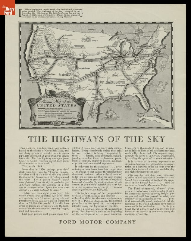
- "Highways of the Sky," Advertisement Promoting Commercial Air Travel on Ford Tri-Motor Airplanes, 1928 - As the United States expanded in the twentieth century, air travel became an efficient alternative for the transportation of goods, services, and people. This advertisement compares the early days of commercial aviation to the early days of transcontinental rail travel, and predicts that air travel will become hugely popular -- especially on the Ford Tri-Motor airplane.
- 1928
- Collections - Artifact
"Highways of the Sky," Advertisement Promoting Commercial Air Travel on Ford Tri-Motor Airplanes, 1928
As the United States expanded in the twentieth century, air travel became an efficient alternative for the transportation of goods, services, and people. This advertisement compares the early days of commercial aviation to the early days of transcontinental rail travel, and predicts that air travel will become hugely popular -- especially on the Ford Tri-Motor airplane.
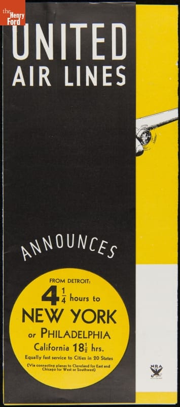
- "United Air Lines Announces from Detroit 4 1/4 Hours to New York or Philadelphia," 1934 -
- 1934
- Collections - Artifact
"United Air Lines Announces from Detroit 4 1/4 Hours to New York or Philadelphia," 1934
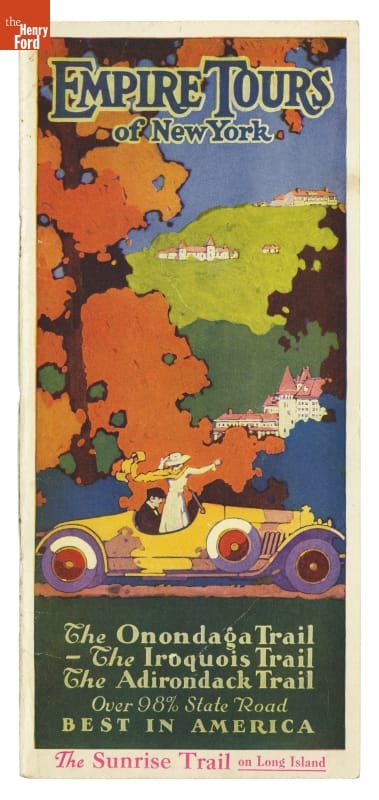
- "Empire Tours of New York," 1925 - Scenic highway "trails" helped motorists organize the diversity of sights encountered in various regions of the country. This travel guide described four distinct motoring "trails" in New York State, each with its "own individual charm and providing the most interesting scenery, the finest concrete and macadam roads, historical landmarks, and the most convenient and comfortable hotels and inns."
- 1925
- Collections - Artifact
"Empire Tours of New York," 1925
Scenic highway "trails" helped motorists organize the diversity of sights encountered in various regions of the country. This travel guide described four distinct motoring "trails" in New York State, each with its "own individual charm and providing the most interesting scenery, the finest concrete and macadam roads, historical landmarks, and the most convenient and comfortable hotels and inns."